Mount Triglav
Mount Triglav
At 2,864 m, Triglav is Slovenia's highest peak and its national symbol. Climbing this summit in the Julian Alps is a rite of passage for Slovenes and an accessible challenge for experienced hikers.
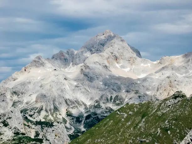
Mount Triglav (2,864 m) is Slovénie's highest peak and the country's national symbol — it appears on the flag and coat of arms. Located in the heart of the Triglav National Park, in the Julian Alps, it attracts thousands of hikers each year. Climbing this summit is considered, in Slovene culture, a rite of passage that every citizen should accomplish at least once in their lifetime.
Practical Information at a Glance
- Access: Several ascent routes from the Bohinj, Kranjska Gora, and Trenta valleys; the most frequented depart from Pokljuka or Vrata valley.
- Recommended duration: Minimum 2 days (overnight at a mountain hut) for the classic ascent.
- Season: July to September for safe conditions; outside this period, alpine equipment is mandatory.
- Equipment: Helmet, harness, and via ferrata gear recommended on equipped sections (summit ridges).
- Mountain huts: Several staffed huts (koče) dot the routes; reservation essential during peak season.
- Park entry: Free access to trails; hut overnight fees apply.
What You'll See
The summit consists of three rocky peaks — hence the name Triglav ("three heads"). The panorama from the summit spans the Julian Alps, the Italian Dolomites on clear days, and the Adriatic Sea. The ascent passes through varied landscapes: pine forests, alpine meadows, limestone karst, and vertical rock faces equipped with cables and metal rungs.
History and Context
Triglav is mentioned in texts dating back to the Middle Ages. The first documented ascent dates to 1778, carried out by a team of Austrian naturalists led by Lovrenc Willomitzer. In the 19th century, the summit became a symbol of the Slovene national movement. The national park, established in 1924, is the oldest and only national park in Slovénie; it covers approximately 880 km².
Highlights of the Visit
The Summit Ridge and Aljažev Stolp House
At the summit stands the Aljažev stolp tower, a tiny metal cabin erected in 1895 by priest Jakob Aljaž to symbolize Slovene sovereignty over the peak. It has become a site of cultural and sporting pilgrimage alike.
Vrata Valley
A classic starting point, Vrata Valley offers a direct view of Triglav's north face, one of Central Europe's great alpine walls. It is accessible by car from Mojstrana.
Lake Bohinj and the Southern Approach
The route from Lake Bohinj traverses alpine meadows and historic mountain huts. It is the longest route but also the most gradual, suited for experienced hikers without specific alpine experience.
The Seven Lakes Ridge (Dolina Triglavskih jezer)
This high-altitude karst plateau is home to seven glacial lakes. The route connecting them forms one of the park's most beautiful traverses, often combined with the Triglav ascent.
Photography Tips
Morning light is ideal from Vrata Valley for photographing the north face. At the summit, the first hours after dawn offer maximum visibility before clouds roll in. Bring a wide-angle lens for panoramas and protect your equipment from the wind and humidity common at altitude.
Location and Access
Triglav lies in northwest Slovénie, approximately 90 km from Ljubljana. The main gateways are Kranjska Gora to the north, Mojstrana (Vrata Valley) to the east, and Bohinj to the south. No road reaches the summit; access is exclusively on foot. Seasonal shuttles serve certain departure parking areas from Bled and Bohinj. Accessibility for those with reduced mobility is limited to valley floors.
Nearby Attractions
- Lake Bled — glacial lake with its island and castle, approximately 25 km to the east.
- Lake Bohinj — Slovénie's largest natural lake, starting point for southern routes to Triglav.
- Kranjska Gora — mountain resort at the foot of the Julian Alps, northern access to the park.
- Vintgar Gorge — gorge carved by the Radovna River, accessible from Bled.
Frequently asked questions
No, but good physical fitness and mountain hiking experience are essential. The summit sections are equipped with cables and metal rungs; a harness and helmet are strongly recommended. A local guide is advisable for those new to alpine terrain.
July to September, when trails are clear of snow. August sees the most visitors; early July and September offer fewer crowds and generally stable conditions.
Technically possible from certain nearby starting points, but not recommended. Most classic routes require an overnight stay at a mountain hut for a safe and comfortable ascent.
Yes, in July and August advance reservation is essential, sometimes several weeks ahead. The mountain huts (koče) are staffed and offer meals and dormitory-style accommodations.
Yes. Bled serves as a practical logistics base: approximately 25 km from the Vrata Valley trailhead, the town offers a wide range of accommodations. Plan at least 3 to 4 days to combine both.
Yes, with no particular restrictions. The Aljažev stolp tower and the 360° panorama are the most photographed subjects. Protect your equipment against strong winds or sudden fog.
Interested in this visit?
We can include it in your personalised itinerary.